
Ok, I need you to work with me here for this announcement: think of the Top of the Pops music for the chart rundown, then in your best shouty DJ voice bellow “…. and straight in at number one …. it’s Slaggyford and Knarsdale”. No, not a musical duo but two villages along the route of my new favourite walk.
The 5.4 mile circuit in the South Tyne Valley has gone straight to the top of my Hiking Hit Parade, although admittedly the list changes frequently as I find a new route or re-visit an old one and remember its delights.
This week’s favourite is a couple of miles from Isaac’s Tea Trail, but there’s a strong chance that Victorian tea pedlar Isaac Holden would have walked the area. Approximately half the route is an old bridleway linking several farms, passing right by the farmhouse doors where Isaac could have knocked to sell his tea.
I began in Slaggyford, walking south along the A689 for a short distance then turning off to reach a bridge across the River South Tyne and follow a quiet lane. The route then headed up a driveway to pass some swanky farm buildings converted to holiday lets. I felt I should have wiped my boots before crossing the immaculate yard.
Veering northwards and uphill, I soon reached a soft and sinuous grassy track. Following the contour of the valley side, it enticed me on to the next curve, the next gateway, the next view.

The autumn colours weren’t yet at their peak, but there was plenty of variation in foliage and berries to signpost the coming season. On the valley flank above me the heather had dialed down its purple to an indescribably rich and subtle hue. I could hear the River South Tyne down to my left, and it appeared from time to time.
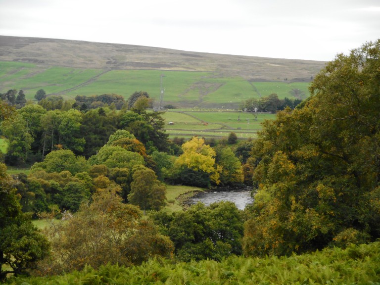
The path undulated slightly but was gloriously easy walking, due to its probable origins as a track for carrier ponies and carts servicing a lime kiln at one of the high points. Just before a farm called The Bog it passed an area of juniper bushes which has been classified as a Site of Special Scientific Interest. The citation says it’s one of the best examples in Northumberland of a scarce scrub-type of juniper. Experts have estimated that there are hundreds of bushes on the hillside, most of which are between 70 and 120 years old.
Juniper is, of course, a primary ingredient in gin. Realising that my route would pass an excellent pub later I decided that it might help these plucky rare shrubs grow if I drank a toast to them with a G&T. This spurred me on along the lovely grassy track which became a tarmac farm driveway. The final steep descent to cross a stream caused my knees to complain, especially the right one which had been stung by a wasp the day before (to be fair to the wasp, I was kneeling on it at the time).
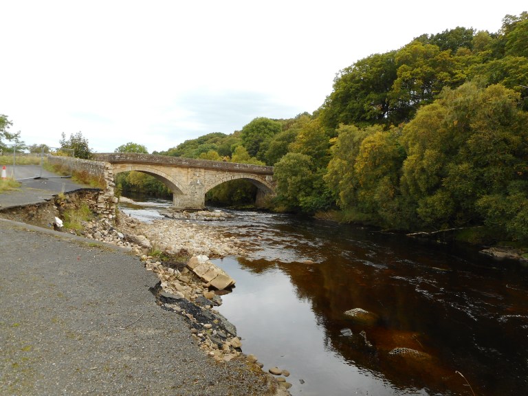
I reached Eals Bridge across the South Tyne, where the flood damage of the storms in winter 2015/16 is still evident. Record-breaking rains washed out 60m of wall and part of the road.
A quiet lane took me southwards with clear views across the river to the valley-side I had just traversed; I love spotting land features and relating them to the wider scenery and to the OS map. Also very clearly on my map was a giant blue beer mug marking the Kirkstyle Inn, purveyor of gin and tonic.
By the time I’d reached the pub my caffeine craving had overtaken my gin desire and, remembering I had to drive home, I opted for the fruit of the coffee tree rather than the juniper bush.
Next door to the pub is St Jude’s Church, with a footpath through the graveyard that leads to a route across three fields to reach the South Tyne Trail. This disused railway line runs from Alston to Haltwhistle (see blog postings April 3rd 2016, April 19th 2016, May 26th 2016, June 6th 2017) and is brilliant to walk or cycle.

Narrow gauge trains (steam and diesel) run on 3.5 miles of track from Alston to Lintley, and very soon will be running further north on an extension to Slaggyford. The South Tynedale Railway has almost completed work to restore the station and it looked as if the last few sections of track would soon be in place.
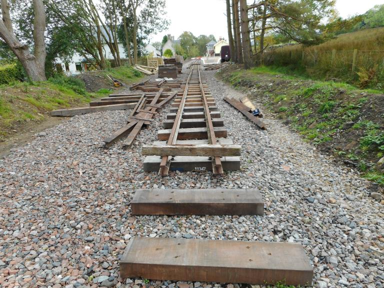
There’s already a vintage carriage labelled ‘buffet car’ parked beside the platform, so the prospects look good for a caffeine top-up at the end of this fabulous walk when the station re-opens.

This map is only intended as a rough guide to the location of the route. Ordnance Survey OL43 Hadrian’s Wall, Haltwhistle and Hexham has all the detail.
There’s more information about Isaac’s Tea Trail at http://www.allenvalleys.com/isaacs-tea-trail/

Love the Kirkstyle Inn, great food and ale as well as g&t 😉
LikeLike
Aha – so you’re Oldie In The Pub as well as Oldie Outdoors! It is indeed a great pub, Andrew, in a wonderful setting.
LikeLiked by 1 person
Very much so 😉 I love the story of how it’s supposed to look like a church!
LikeLike
One of the top wooded valleys in the North Pennines AONB. Great to see shots of the new station at Slaggyford thanks for the sneak preview Anne. Next time I am at the pub I will try the gin in your honour.
LikeLike
A perfect Henry walk by the looks of things Anne and the revitalised Slaggyford Station could most certainly be an inducement for other members of our family to venture to the Northlands.
LikeLike
The North Pennines truly has something for everyone – and every dog.
LikeLike